.png)
As Suicide Basin expands, knowledge about its outbursts does the same
- Jasz Garrett

- Aug 31, 2025
- 10 min read
The flood’s peak this year was bigger for two reasons: it occurred shortly after a large rainstorm and water drained faster
By Jasz Garrett
Juneau Independent
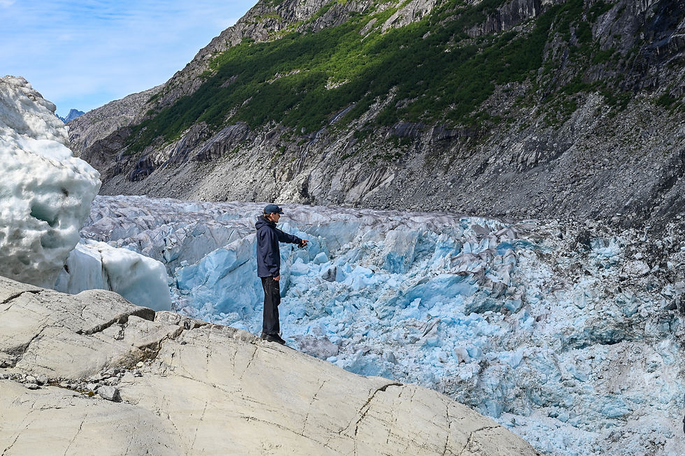
With silt-caked hands, University of Alaska Southeast researchers Eran Hood and Sean Fagan climbed steep rocks to peer into an empty Suicide Basin, hours after the Mendenhall River had crested below.
In just two days, about 15 billion gallons of water were released from the side basin above the east face of the Mendenhall Glacier. The torrent of water unleashed into the Mendenhall River, which peaked at 16.65 feet on the morning of Aug. 13, rushing at 51,100 cubic feet per second.
“Where we just walked was all underwater,” said Hood, an environmental science professor. Broken, blue shards of ice from the Mendenhall Glacier protruded into the basin below the sheer ledge on which he stood. A day earlier, he flew overhead in a helicopter to examine the release with Aaron Jacobs, a senior service hydrologist for the National Weather Service Juneau.

Hood returned the afternoon of Aug. 13 to trek the same path the glacial lake had taken to drain. Fagan, a university research professional studying glacial changes, accompanied him. Geophysics professor Jason Amundson managed the university’s specialized drone on the ice above.
The university, National Weather Service, and U.S. Geological Survey work closely year-round to monitor Suicide Basin.
UAS began a drone program in 2018 to map Suicide Basin. The most critical timing for the drone survey is after the basin has emptied, allowing scientists to detect impacts to its storage capacity. The drone also mapped the basin when it was full, allowing a comparison. In addition, a global positioning system positioned on the Mendenhall Glacier measures how quickly its ice is retreating into the basin. But glacier melt is not the only consideration. Other ice flows in, so the drone measures changes in surface elevation.
The university team and its partners have been awarded a five-year grant to assess current and future outburst flood hazards and improve glacial flood forecasts across northwest North America.
Hood and Amundson said it was their eighth trip to the basin this year. They have been studying it since 2012, following the first glacial lake outburst flood in 2011. The understanding of the project’s scope, as well as its funding, was limited until the flood reached unprecedented levels in 2023.
Fagan was seeing Suicide Basin for the first time. He created the Juneau Glacial Flood Dashboard, which launched in May, providing an interactive view of the flood inundation maps contracted by the City and Borough of Juneau.
“It’s insane,” he said. “Having stared at a computer screen for nine months looking at the basin to make the website, I never expected it to be this big in person — just because of the fact that I've stared at it for hours and hours on a computer screen. Probably days and days on a computer screen.”
This year, Suicide Basin reached its threshold at 1,365 feet on Aug. 10, when it began spilling over the top of the Mendenhall Glacier, which acts as a natural ice dam. The glacial lake built enough pressure to force its way underneath the glacier before the floodwaters were released through the overflow channel into Mendenhall Lake, causing the outburst flood. The lake then directed the floodwaters down the Mendenhall River, inundating roads and homes, before the water reached the ocean.
Hood and Fagan took photos as they ventured through the eroded overflow channel, which is 15 feet deeper than last year. Icebergs towered above them, still dripping from the flood. As the water rose in the basin, icebergs floated, and once the release occurred, they were pushed down the flood pathway. Hood, then Fagan, leaped over a crevasse as they made their way down and then back up the channel.


(Photos by Jasz Garrett / Juneau Independent)
As the researchers were surveying Suicide Basin, they received a citywide phone alert at about 3 p.m. that the flood threat had officially ended. For residents in the flood zone, the alert arrived while the sound of trees crashing into the Mendenhall River was still fresh.
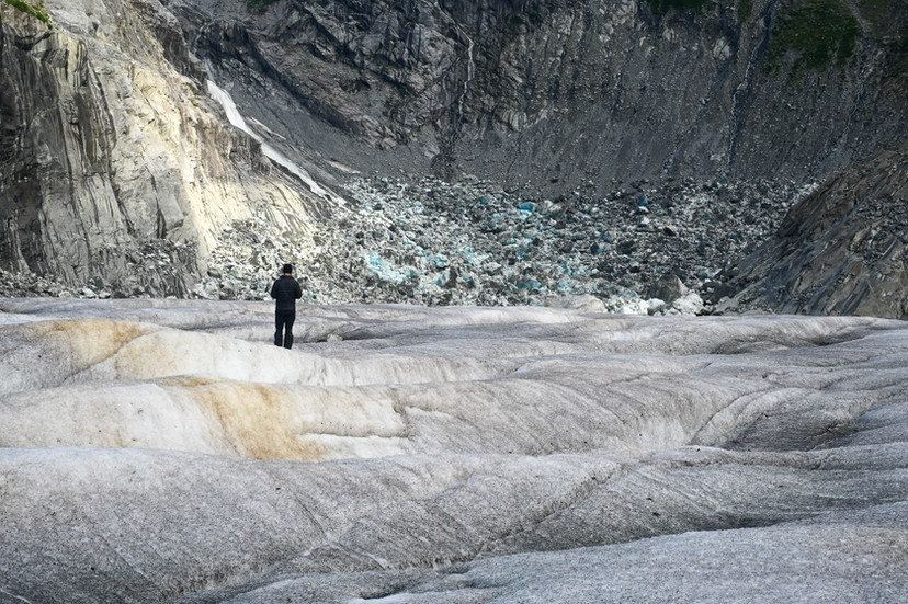
In contrast, the eastern edge of the Mendenhall Glacier was quiet except for the occasional creak of ice, rockfall in the distance, and the whirr of the drone above.
Suicide Basin is continuing to widen and expand into Mendenhall Glacier, Hood said. At the same time, the glacier is receding into the basin.
“The glacier dam itself is also getting thinner, so it’s lower,” he said. “So there’s a bunch of competing processes at play that can make it either hold more or less water.”


(Photos by Jasz Garrett / Juneau Independent)
Facing Bullard Mountain, Amundson gazed over the basin, a deep gorge of ice. He watched the drone pass behind a waterfall of glacial melt.
Cupped between the Mendenhall Glacier and the bare mountain, the basin fills with rainwater, ice, and glacier meltwater every year. Suicide Basin was carved by the rapidly retreating Suicide Glacier, which now hangs above. As it receded away from the larger Mendenhall Glacier, it left behind the rock-and-iceberg-filled valley. The basin is three-fourths of a mile long and half a mile wide.
The drone takes several thousand photographs that it stitches together to create a single image. The drainage revealed the entire shape of the basin. The team then used the GPS and drone to create a 3D digital elevation model of Suicide Basin.
Scars of erosion scoured Bullard Mountain, with a waterline visible where the basin was once full. Amundson was holding a controller that showed the drone’s aerial view, revealing that Suicide Basin was ice only in the hours after the flood’s peak. He said in the August 2024 and 2025 floods, the basin drained entirely to the bottom.

Juneau has reached new record high water levels for the past three years in August. The first devastating glacial lake outburst in 2023 reached an unprecedented crest of 14.97 feet. In 2024, the Mendenhall River broke another record at 15.99 feet. This year, the record-breaking 16.65-foot crest did not cause damage to 90% of homes in the Mendenhall Valley, due to the city’s installation of temporary HESCO barriers. The U.S. Army Corps of Engineers provided the semipermanent levee following the widespread damage to nearly 300 homes in 2024.
Forecasting the glacial lake outburst flood
There’s a much deeper understanding of the basin now, the university team said, even if its capacity is continuing to change.
“The first year in ’23, we did not know it could drain like this, so the prediction was way low, and then it was like, ‘Oh my God, what’s happening?’” Hood said. “Then the next year, it drained a little farther. But we made a good forecast. Last year, we knew the forecast — we didn’t know what would happen for that forecast in the Valley.”
The 2024 flood reached a new high level for which inundation maps were not readily available.
“We’re missing two pieces of information the first year,” Hood said. “We're missing one piece of information (the second year). And then this year, we’re missing no pieces because we knew the volume. We got the forecast really good, and people had the flood maps and knew exactly what to expect.”
The official forecasted peak of the Mendenhall River was 16.6 feet.
This year, the outburst coincided with a rainstorm, creating a complication, Amundson said.
“What happened this year was what we were always worried about happening,” he said.
Rainfall conflicted data, causing the National Weather Service to adjust its forecast time. Early weather service alerts had called for the Mendenhall River to crest in the afternoon of Aug. 13, but the evening before, forecasters adjusted the forecast to be between 8 a.m. and noon.
“The reason for the change (in) crest timing is due to rain masking the start of the subglacial release and refining the initial start time of the event,” a flood alert published by the weather service stated.
According to National Weather Service meteorologist Greg Spann, the official release began at approximately 7:15 a.m. on Aug. 11. It was first detected at 9:20 a.m. on Aug. 12.
The river and lake were already in a minor flood stage due to heavy rain, making the base flow high – 6,890 cubic feet per second — when the outburst began on Aug. 11.
“Luckily, it was at least a little bit delayed,” Amundson said. “The base flow was already starting to drop by the time the peak from the flood hit Mendenhall Lake. So if the peak had happened a day or so earlier, the water levels would have been a bit higher. That’s always been one of our big concerns, if you have a flood line up with an atmospheric river.”
During the rainstorm preceding the announcement of the outburst, Juneau residents noticed a new waterfall pumping into Mendenhall Lake through the Mendenhall Glacier’s overflow channel. They wondered if it was a sign of the flood – it was.
“It was so disorientating, like ‘What is that?’” Hood said. “It was a combination of storm runoff and the release.”
Suicide Basin drained more rapidly this year
The forecast also depended on the rate of rise in Mendenhall Lake, according to the weather service and university researchers.
“It’s kind of like saying how big your car is depends on how fast it is,” Fagan said. “It’s hard for people to understand.”

This year, the rate of discharge in the Mendenhall River increased substantially, Hood said.
“In one hour, discharge went up 3,500 (cubic feet per second),” he said. “Last year, 2,800 was the largest increase in discharge in any one-hour period of the entire flood.”
He said so much water was flowing into the basin that it expanded the conduit under Mendenhall Glacier over time due to pressure before water levels began to drop. Hood said Suicide Basin had roughly the same starting volume as last year, but it released water more rapidly.
“There was a delay at the beginning where the conduit’s just starting to open,” he said. “There’s so much water coming in. It’s not draining. It’s not draining — it’s overflowing. And then the conduit’s opening more, and then that drains it down slightly, and it stops overflowing.”

Future flood risk
Hood said the Suicide Basin outburst flood has behaved in a repetitive cycle for the last three years: “It fills to the top, it overflows — we know the volume – it drains. It fills to the top, it overflows. We know the volume — it drains.”
He believes Juneau has not yet experienced its largest flood, reiterating a statement he first made in 2023. He said he was worried about upsetting people at the time, but from a statistical standpoint, since the flood will last for decades, it will likely continue to evolve. The flood is expected to continue until the Mendenhall Glacier retreats far enough to no longer act as a dam, a process predicted to take 25-60 years.
The variability recorded in other outburst floods around the world makes the size of Juneau’s future floods difficult to predict, Hood said.
“Given the records that I’ve seen over time and the way these things evolve, you would see these floods in the first 15 years, and then it’s all downhill from there,” he said.
Amundson said Juneau could already have experienced its most significant flood. Hood said he wouldn’t rule it out; he just believes it to be unlikely.
Hood has trouble imagining the flood could become much bigger, such as doubling in size, because Suicide Basin sits on bedrock. If every single iceberg melted, he said, only 10% of the basin would be gone.
“What we don't know is if you could look back 30 years from now and see all the flood peaks, are the ones that we're seeing now, like, kind of normal? Are they on the high end, or is there another place that we can go?” Hood said.
Amundson said it is possible to assess the potential for future floods by comparing the differences between a full and empty basin.
“What we know from other glaciers around the world and what we've observed here is that the peak discharge during the flood is really strongly correlated to the volume of water, which makes sense,” he said. “So it's almost a linear relationship. So if we know how much water is going to drain, we can give you a pretty good estimate of how big the flood is going to be. So then what we're trying to do is to understand, ‘Is the basin getting bigger or smaller, or is it staying roughly the same?’”

The Army Corps of Engineers has estimated permanent flood mitigation is seven to 10 years away. One of the factors they must consider in a long-term study is that more basins have already been identified further up the Mendenhall Glacier. The closest one is still covered by ice.
“We’re going to do some radar surveys to try and figure out how thick the ice is there, could it actually hold a lot of water?” Amundson said.
He said in some ways it would have been nice to have surveyed Suicide Basin decades ago because, for a long time, the issue was not knowing the depth due to it only draining halfway.
Suicide Basin had already begun to refill in the days following this year’s flood.
Throughout the entire time the floodwater is pushing through and widening the overflow channel, the Mendenhall Glacier is attempting to “crush it closed.” Once the water has completely drained, ice closes the conduit, allowing the basin to refill.
“The drainage channel underneath the glacier will reseal itself with ice,” Hood said. “The pressure of the ice above it will just deform and close because ice that’s under a lot of pressure is really good at deforming.”
Glacial melt and rainfall will continue to replenish Suicide Basin, with a less severe outburst possible this fall. A second release in October 2024 caused the Mendenhall River to crest at 10.77 feet.
The researchers plan to make another trip to the basin in the fall. They will also present their research at UAS Egan Library, possibly in October. An event report from UAS, the National Weather Service, and the Geological Survey will be available on the Suicide Basin monitoring page in the coming weeks.
• Contact Jasz Garrett at jasz@juneauindependent.com or (907) 723-9356.


(2)_edited.jpg)