.png)
Looking beyond this year's glacial lake outburst flood
- Jasz Garrett

- Oct 12, 2025
- 9 min read
Despite this year’s success, scientists continually refine field and modeling approaches and learn new things each flood

By Jasz Garrett and Ellie Ruel
Juneau Independent
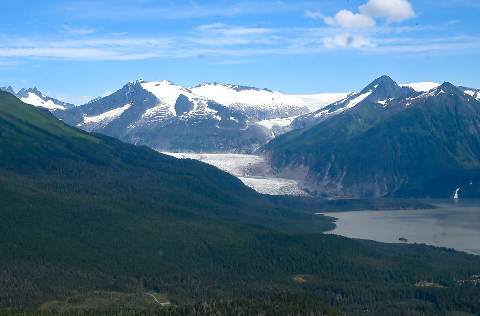
University of Alaska Southeast professors have been studying Suicide Basin since 2012. They say they should have known the outburst floods would reach the extreme levels they have in the past few years, but now others can learn from them.
In 2018, the team researching Suicide Basin was still able to walk across a remnant ice sheet. This year, the U.S. Army Corps of Engineers could hover a helicopter over the rocky bottom, allowing passengers to jump out. That is only one indication of how much has changed.
The future of Juneau’s glacial lake outburst flood was explored at a University of Alaska Southeast Evening at Egan lecture on Friday, where seats overflowed with more than a hundred community members eager to hear the latest findings. Seats were so full that people stood in the back of the lecture hall and sat on the floor, with extra seating available in the Egan Library. About 50 people watched the livestream remotely.
The numbers released by UAS researchers Eran Hood and Jason Amundson will be finalized over the winter. Preliminary calculations appear to show that Suicide Basin’s storage capacity increased by 20% in the last five years.
“Little bit scary to think about it continuing to increase 10,000 acre-feet every five years,” Amundson said. “But I think the thing that should give you at least a little bit of comfort is that there’s not a lot of floating ice left in the basin.”
Iceberg melt was a major driver of basin expansion over the last five years, and “with only 6,000 acre-feet left, it's hard to imagine that we’re going to gain a lot more storage capacity through iceberg melt,” Amundson said.
“It turns out that the volume of ice in the basin is one of the really important parameters that determines whether the basin is getting larger or whether the basin is getting smaller,” Hood said.
The Mendenhall River crested at a record-breaking 16.65 feet on the morning of Aug. 13. The high discharge was due to the outburst taking place shortly after a large rainstorm. Amundson said during August’s outburst, the basin released about 57% of the volume of Mendenhall Lake.
“If you look at a map, you wouldn’t guess that, because Suicide Basin looks a lot smaller, but it’s also much deeper,” Amundson said.
The National Weather Service, UAS, and the U.S. Geological Survey collaborated to predict the flood’s timing and peak discharge using data from drone surveys and time-lapse photography.
Hood and Amundson may be the most recognizable faces of the ongoing research at Suicide Basin, but they made it clear the monitoring effort is made possible through interagency collaboration.
“He’s the only one that has the technical mountain skills and technical science skills to put a camera in the basin that allows people to see into the basin in real time,” Hood said, calling out USGS hydrologic technician Jamie Pierce in the audience.
Hood said the research team has witnessed substantial change over the approximately 15 years they have been studying Suicide Basin. To understand how the flood will keep changing with time, scientists need to understand its volume.

Competing factors are at play: the Mendenhall Glacier’s ice dam elevation, the dam’s location, and how many icebergs are in the basin. While Amundson said he expects iceberg melt to become insignificant in the near future, he called what happens with the ice dam’s location a “wild card.” What it comes down to, he said, is how quickly the glacier is thinning and if the basin will expand further into the glacier.
Amundson explained that while the preliminary data had “large error bars,” the reduction in floating iceberg volume increased the basin’s volume by roughly 12,000 acre-feet, the basin itself expanded by about 6,400 acre-feet, and the ice dam thinning created a volume loss of approximately 8,500 acre-feet. That adds up to a total carrying capacity increase of 9,900 acre-feet, but how the glacier thinning will impact future numbers is uncertain.
“Even though the basin has only retreated maybe 100 meters or so in the last five years, I think maybe the concern and the challenge is with this amount of thinning, we don't quite understand what's going to happen in the coming years,” Amundson said.
But the researchers have tools to understand the dynamics of the outburst. According to Hood, one of the most important is drone mapping. Amundson said UAS has completed almost 50 drone surveys since 2018 and plans to keep doing so. The most recent drone survey was Aug. 13 to map the empty Suicide Basin. Mapping was also done a week earlier when the basin was near its capacity.
“Basically we fly a drone over the basin, and the drone has a pattern where it grids and it covers the entire basin,” Hood said. “It takes about 2,300 photographs, and if you zoom in on one of those grid lines, you can see that the photographs all overlap each other.”
That overlap ensures that every pixel within each image is captured multiple times in different positions in space. By calculating the distance between each pixel’s location and cross-referencing with the drone’s GPS, the researchers can determine the exact elevation of each point and construct an accurate three-dimensional elevation model of the bottom of the basin, referred to as an orthoimage.

According to Hood, the orthoimages allow them to track changes in the basin and provide a more accurate volume measurement on which to base their forecasts.
“One of the most important variables is the shape of the basin, right?” Hood said. “As a forecaster, you would say this is a big bowl of water that's going to release. And if I know exactly how much water is contained in the bowl, that's going to make my forecast much, much better than if I'm trying to guess.”
The glacial lake outburst floods occur when the basin fills to the point where the ice dam releases. The hydrostatic pressure lifts the glacier’s ice, allowing more than 16 billion gallons of water to flow under it. Another significant factor in predicting how floods will impact downstream communities is determining the width of the escape channel, as it affects how quickly the water can drain.
“We can't see the conduit,” Hood said. “Because the ice is so thick here that soon after it drains the conduit, the overburden closes the conduit.”
At this point, Amundson and Hood said they believe they have “a really good grasp” of the basin volume and flood mechanics, but it’s difficult to understand year-to-year variability, partially because it’s challenging to observe the conduit.
During the August flood, forecasters had some difficulty determining when the river would peak since the excess rainfall masked the initial release underneath the glacier. The time of the peak was shifted back after researchers realized the basin was overtopping and releasing at the same time. The official release began at approximately 7:15 a.m. on Aug. 11 and it was first detected at 9:20 a.m. on Aug. 12.
“Usually when there's no rainfall, the switch is pretty clear. It's like, ‘Oh, it's starting to go underneath.’ In this case, the whole time it was overtopping, or a lot of the time, it was also releasing underneath,” Hood said.
Hood said the rainfall may have also kept the water level in the basin high longer than usual, allowing the conduit to widen through thermal erosion and create a faster outburst of water.
According to Hood, the closing of the conduit is what creates the minor second outburst events Juneau usually experiences in the fall, since the basin begins to refill days after its major outburst. This year, the second outburst crested at 9.6 feet on Sept. 15, about a month after the major flood.
The university research team also includes scientists from the University of Alaska Fairbanks, the Alaska Climate Adaptation Science Center, and multiple postdoctoral researchers.
Lifespan of Suicide Basin
UAS is working with UAF research professor Gabe Wolken to collect the ice thickness data of Mendenhall Glacier and model glacier evolution. It’s part of the current mission to determine Juneau’s position in relation to the anticipated peak flood event. Wolken is a research scientist and manager of the Climate and Cryosphere Hazards Program at the Department of Natural Resources Geological and Geophysical Surveys.
A radar, resembling a sling load, flies a grid and transmits electromagnetic waves that penetrate through the ice. Some of them bounce off the glacier’s surface and come back, while some pierce through to the bottom before coming back. Wolken has scanned all of the lower elevations of the Mendenhall Glacier down to 1,200 meters and still needs to fly the radar at higher elevations.
The data is still being processed, but Amundson said initially, it suggests the bed of the Mendenhall Glacier is below sea level, which is consistent with UAF Geophysical Institute glaciology studies in the 2000s. A bed of a glacier refers to the layer of ice at the bottom, which is formed from snow accumulation over many years.
“It looks like the glacier’s retreating out of Mendenhall Lake right now, but I expect at some point in the future there’ll be another lake further upstream,” Amundson said.
Warming temperatures in Juneau, consistent with the rest of Alaska, have initiated a decades-long retreat of Mendenhall Glacier, according to UAF. Once Wolken finishes processing the data, a map will be available.
By knowing what the glacier surface elevation looks like and where the boundary of the glacier is, researchers can better understand how the basin is changing over time.
“There is this life cycle of outburst floods that they start off small, the basins are going to get bigger, and then they’re going to get smaller over time,” Amundson said in an interview.
He said while work has been done about the physics of outburst floods and more documentation is starting to exist about how they change over time, there hasn’t been a description of outbursts as an ephemeral part of the landscape.
“We didn’t have outburst floods, Mendenhall’s retreating and thinning, now we have outburst floods,” he said. “At some point in the future, we’re not going to have them again.”
When the floods cease depends on the retreat of Mendenhall Glacier’s ice dam.

Flood dashboards and community feedback
Outburst floods are happening all over Alaska and other glacierized areas. Looking back, Hood said they should have known this was going to happen, but they didn’t. Now their knowledge can provide groundwork for the entire state: an Alaska Glacial Lake Flood Dashboard is in the works, part of a project funded by the National Science Foundation. It can be used to predict where “all the new Suicide Basins are going to occur.” The state dashboard is expected to be released this fall.
“All the other places where it could happen in the future, the modeling that we’ll do will help to inform people to say, ‘Hey, watch out in 30 years if you live downstream of this because it looks like when this side glacier detaches, there’s a chance that you might have a situation like this,” Hood said.
In May, the University of Alaska Southeast launched the Juneau Glacial Flood Dashboard, which received about 15,000 page views on the day of this year’s record-breaking flood. Feedback sessions on Sunday and Tuesday aim to find ways to improve the resource. Sunday’s session will be at the Mendenhall Valley Public Library from 3:30 to 5 p.m., and Tuesday’s virtual session will be held on Zoom from 7 to 8 p.m. An online form to submit thoughts is also available on the website.
In an interview, Kim Titus said his neighbors have lost land from river erosion during the last two floods, and he’s concerned about the problem worsening, especially since he doesn’t have HESCO barriers on his property. This year, his house didn’t take on water, but Titus said it was a near miss. For him, the flood maps were a helpful source of information that allowed him to prepare.
“I can’t thank you and everyone enough. Our property was flooded this year on River Road, and your modeling and everything you’ve done is super. Thank you,” Titus told Amundson and Hood, prompting heavy applause at the end of the event.
• Contact Jasz Garrett at jasz@juneauindependent.com or (907) 723-9356. Contact Ellie Ruel at ellie.ruel@juneauindependent.com.


.jpg)